
PCT - White Pass to Cascade Locks

It didn't take me long after completing the first section of the PCT to start planning for the next. Since summers are now being spent in Alaska, it only spring and fall are left for hiking. This limits the trail sections available. As a Section Hiker, I can pick and choose the area to hike based on the best season and whether it's best to hike north to south or vice versa. Southern California is best in the spring, when water is more available and the weather cooler. Fall can be great in most areas, though weather is not as dependable.
Perhaps a little over confident after the success of my spring hike, I decided to take a chance and planned an early fall hike in Southern Washington. I would follow this by another section in Southern California. Helping to fuel all my planning was a high school reunion in Las Vegas, scheduled for the third weekend in September. I developed a plan to hike from White Pass to the Columbia River (148 miles) from September 8 – 19, fly to Las Vegas for the reunion, then hike from Cajon Pass to Hwy 10 (134 miles) from September 21 – October 3rd. And if all was going well, take the Tram back up to Mt. Jacinto and finish the 30 miles I was unable to complete in the spring.
In addition to getting provisions together, packed and mailed for pickup along the trail at strategic points, there was the logistics of getting to and from trail heads. There is no public transportation to White Pass, so someone was going to have to drive me, 215 miles from Port Townsend. It was going to take someone special to help me out. I had gotten to know Peggy who was part of a group of women I hike with every month, and I thought, “what the heck?” I'll just ask. And she said yes! I told her that I'd love her to join me for a day or two on the trail if she was game. I enlisted my friend Dave, who lives in White Salmon, 30 miles south of the PCT to resupply me on day 6. And my friend Chuck, who lives on the Columbia River, agreed to pick me up at the Cascade Locks on the Columbia River. I could get some kind of transportation into Portland for my flight to Las Vegas. So that took care of that section.
Getting to Cajon Pass for the section after Las Vegas was my next challenge. I could get transportation to Victorville, 20 miles north of Cajon Pass, so I put out a request on the PCT Forum page for a ride to the Pass and actually got 3 responses from “Trail Angels”. That was easier than I expected. At the other end, another Trail Angel agreed to give me a ride from Cabazon on Hwy 10 to the Tram. I would fly back to Seattle from Palm Springs. Now all I had to do was hike.
Normally I wouldn't depart Cordova, AK, home-port for Tamara, until the first of October, but due to necessary boat yard work, we had not planned on an ambitious cruise this summer. I arranged to fly back to Seattle on Labor Day. That would give me 4 days to get ready for the hike. The weather forecast was looking good except for the third day on the trail where wind and rain were forecast.
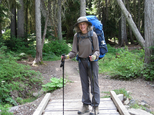
Peggy picked me up at 7:30 am on Saturday, Sept 8th and we were at White Pass by noon. I was glad that Peggy had decided to hike with me to my first camp, spend the night and return the next day. I had decided to hike only 5 miles the first day, putting us directly over the White Pass Ski area. Since I was hiking north to south, and the majority of Thru Hikers were transiting Washington state northbound at that time, I decided to keep track of the number of Thru Hikers I encountered each day.
I had been following the trail journals online of some of the hikers I had met in the spring, focusing on the section I would be hiking to learn of any areas to which I should pay particular attention. One area kept coming up – a 3 mile section of the trail 17 miles south of White Pass. The trail traversed the spine of a ridge, was very steep and in some places less then a few feet wide. As I began meeting hikers who had just hiked that particular section I began to hear stories of how “scary” it was – 800 vertical feet in less than half a mile on very lose rock. I began to realize that if the weather held I would be doing that section in bad weather, so before the first day was over I was thinking that I might have to take a day off on day three.
Peggy was planning on just “cowboy camping” that night, that is to say sleeping in her bag on a space blanket and her pad, under the open sky. But when she opened up the space blanket it totally disintegrated! Luckily there was plenty of room under my fly sheet. The mosquitoes were out that evening and we sat wrapped in clothes with bug juice on our hands and faces playing cards. Just before sunset we could hear an incredible thunder and lightning storm to the south, moving east. (The next day, when I asked two women who had camped at 7,500 ft. how it was, they remarked “interesting”.) By the time we got into our bags the mosquitoes were gone. There were rain showers off and on most of the night.

Peggy and I said our farewells in the morning – THANK YOU Peggy for the ride and companionship! - and I was off on my own. A hike of 10 miles put me in position to do the difficult section the next day weather permitting. Going against the flow of Thru Hikers made it easy to keep a record of Thru Hikers vs. Section and short hikers. I also found it interesting to also note when the Thru Hikers had left Campo, on the Mexican border, and how many miles they were hiking per day. Since they had just hiked the difficult section, I'd ask how it went. The best advice I got was from a guy who sounded like he was from New Zealand, and who noted that since I'd be hiking UP the steep ridge it would be much easier than hiking down. Made camp night 2 in a nice clearing. About 10:00 pm, in the dark, 2 people came in and camped. I kept wondering how they had been able to hike a very difficult section in the dark! And it was now very windy and rainy.
I was in no hurry to leave in the morning, since it was still very windy and the visibility poor due to low clouds. At 11:00 am I began thinking I'd check it out and stop if conditions were bad. I got about a mile and ran into a man about my age. He said that the conditions ahead were difficult, he'd gotten blown over a few times, but hey, go for it. Right behind him was a couple from the Czech Republic who did not recommend proceeding until the wind laid down. He said that he'd done a lot of mountaineering and had never feared for his life until then! That settled it – I would make camp just up the trail and wait until the next day. My camp was in view of the trail, and during the the day I talked with most of the hikers who passed. It was unanimous - after more than 2,000 miles this was the worst section yet. One girl said she thought she was going to die three times! About 2:00 pm I decided to hike further up the trail just to check it out. I ran into a women from Newfoundland who, when asked about the trail said, “I'm from Newfoundland and love the wind and fog! On the exposed ridges where the wind was the strongest I'd just hunker down, wait for a break and then go.” She definitely had the right attitude.

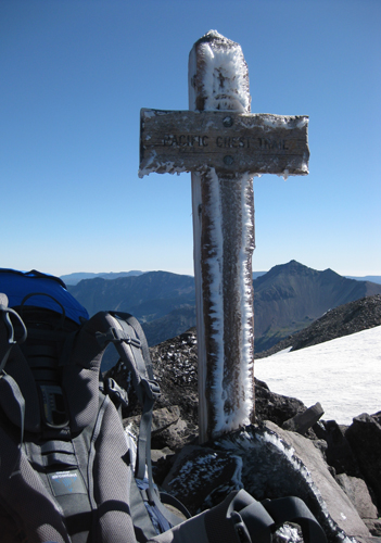
I woke up the next morning at 5:30 am to complete silence and a clear sky, and was on the trail at 7:00 am. After all the stories about this next section of the trail my plan was to go slow and place each foot carefully.
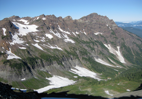
The summit was reached at 11:30 am without encountering anyone heading north. I was glad that I was climbing instead of descending the last half mile. What a beautiful day! The views were incredible - so glad I waited.
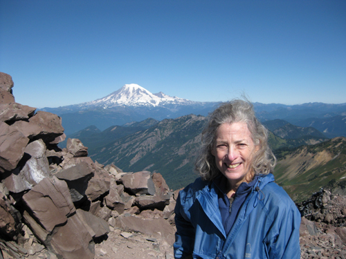
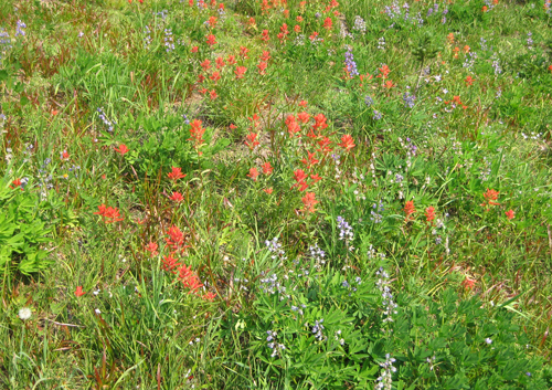
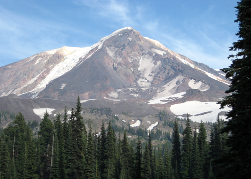
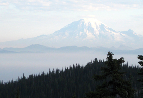
At the summit, I met a man climbing up from the south who was out for 4 days of hiking. On just the other side is Snow Grass Flats, a popular area for hiking, and one worth visiting again. The rest of the day's hike was spent taking in the views of an area called the Goat Rocks, the abundant wildflowers, and Mt. Adams to the south.
I was encountering 10 – 15 Thru Hikers a day, all intent on making 30 miles a day, and reaching the Canadian Border before the bad weather settled in. The forecast was sunny and warm for the next week. I was happy to put in 15 miles a day.
On Day 6 I learned of the fires on the south flank of Mt. Adams. The day before I had noticed a red haze around the sun late in the afternoon, but stupidly I wasn't thinking fires. Peggy and I had talked about strategy if I encountered a fire, this still being fire season. The trail was open but hikers coming from the south were experiencing heavy smoke and ash at lower elevations. Mid-day I stopped for lunch at a beautiful meadow directly under Mt. Adams to the east. Within a short period of time a plume of reddish smoke appeared on the south flank, moving north. I decided it would be best to keep moving and as I was packing up three women came along on horseback. They were camped on a forest road about 5 miles off the trail. It was reassuring that if the winds changed, and I needed to make a quick get away, I could get to the road and have a way out. That evening from my camp I could see Mt. Adams and the smoke had cleared off.
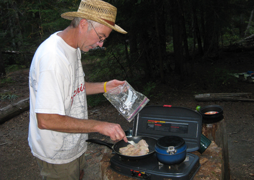
Day 7, Friday, was the day I was to rendezvous with our friend Dave for resupplies. Originally it was planned for Thursday, but due to my one day delay I was behind. I had asked a hiker heading to White Pass to call Dave and let him know that I wouldn't arrive until Friday. I arrived at 11:30 am after 10 miles of mostly downhill, not knowing if Dave got the message. I was soaking my feet and washing socks when Dave showed up. I had not encountered any smoke, but Dave said that on the road up from White Salmon he had passed through lots of smoke. It was another 5 miles to that evening's camp and Dave continued on and met me at my camp, one mile off the road. He had been fishing the week before and had fresh albacore, couscous, and wine that he would prepare for me for dinner. What a treat! As Dave prepared dinner I dealt with my resupplies. Thank you Dave!
I was now half way, out of the high country and more or less back in civilization. The trail would cross at least one road everyday, and ,with the weekend starting, there were numerous people about. Also, being bow season, hunters were around. Since I had lost a day I had to finish on the 19th in order to catch a flight that evening to Las Vegas. The weather forecast was for sunny skies, I was doing 15 miles a day, so could meet my deadline as long as I didn't have any physical problems. I was now hiking mostly in forest and on rare occasions I would get a glimpse of Mt. Adams. The fires were still burning, and as the days went by Mt. Adams became more and more obscured by smoke until finally it totally disappeared.
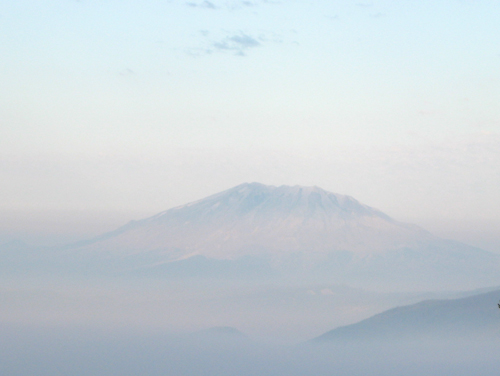 Mt. St. Helens in smoke
On Day 10 I hiked 19 miles! But I paid for it the next day. My knees were beginning to protest against the downhill sections, and my feet were hurting in new places . But I took a couple of aspirin every night and in the morning I was ready to go. The last three days were up all morning, down all afternoon. On the last full day there was a 3,000 ft. descent, the trail was very rocky and my knees were very sore – I just wanted to get into camp. And then, 2 miles from camp, I missed the PCT turnoff and ended up on a dirt road miles off course. A car just happened to be turning around and I asked “Is this the PCT?” No, but the driver offered to take me to the trail, just above my evening camp. I was now 4 miles from the Cascade Locks, an easy morning hike the next day.
Day 13 I crossed the Cascade Locks Bridge into Oregon at 9:30 am, and the end of this section of the PCT. Had I arrived the day before as planned, another friend Chuck was going to pick me up, I'd stay over at his house, and then get into Portland the next day. He also would have my provisions, which I sent to Dave, for the next PCT section in Southern California. Now Chuck would just deliver the provisions and another friend, Anna, would take me to Portland, where she lives. While I waited for Chuck and Anna to arrive, I had a big breakfast at the local cafe. They both arrived about noon, so we went to another cafe where I bought lunch for everyone.
Anna and I proceeded to Portland, where I got a long hot shower and washed my clothes. I know Anna from the American School in Japan – she was a year behind me when we were both high school students abroad. Then Anna made a great dinner and got me to the airport for my Las Vegas flight. Thank you Anna!
Not to bore you any more, and to make a long story short, once I arrived in Las Vegas I decided not to do the next section of trail in Southern California. It was going to be too hot, water sources unpredictable, and though I hike alone, it's nice to know there are other people on the trail. At that time of year, the trail would be empty. With my knees needing some time off, I made the decision to do that section of trail next spring. Instead, after the reunion, I joined a small group who were going to St. George, Utah and Zion National Park for a couple of days. I hadn't been there since 1985! I then flew from Las Vegas to Portland, and spent a few more days with Anna before returning to Port Townsend.
While on the trail I met: 2 Czechs, 3 Kiwis, 2 Brits, 2 Dutch, 2 Japanese and 1 Newfie
Labels: Cispus, Goat Rocks, Mt. Adams, Mt. Rainier, Mt. St. Helens, PCT, White Pass
posted by Editor at 2:49 PM
![]()
![]()


2 Comments:
Nancy - Mark here from Wendaway.
When I was 17, and trying to impress a girl I had my eye on, I told her I would be doing the John Muir Trail by myself.
She said: "By yourself?"
Of course, I replied, not really knowing what that meant.
She said, "The whole thing?"
And I said yes, not really knowing what that might entail.
A month later I finished, having cried my self to sleep most nights, out of loneliness, and fear. Sadly, in some ways, it was the most important adventure in my 65 years.
Your account is inspiring Nancy. Deeply inspiring. I have some idea of what it must be like for you. What a remarkable person.
Mark S.
Sounds wonderful. Congratulations, another section finished!
Post a Comment
<< Home