December 30, 2007: Position Report
Sunday, December 30, 2007 2200 UTC
63 23.23 S 61 33.54 W
Hove to at 9:00 am (local time) this morning 35 miles from Deception Island due to strong SE winds on our nose. Got under way again at 2:30 pm (local time) but headed for Trinity Island. Winds from the SE 20 k, snowing!! Will probably arrive around 2 am (local time). Looking forward to a good night's sleep and getting the boat organized again.
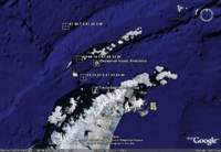
 The above image shows where Trinity and Deception Islands are located as well as the position of the s/v Tarama. Click image for larger view.
63 23.23 S 61 33.54 W
Hove to at 9:00 am (local time) this morning 35 miles from Deception Island due to strong SE winds on our nose. Got under way again at 2:30 pm (local time) but headed for Trinity Island. Winds from the SE 20 k, snowing!! Will probably arrive around 2 am (local time). Looking forward to a good night's sleep and getting the boat organized again.
Labels: Antarctica, Tamara, Trinity Island


0 Comments:
Post a Comment
<< Home